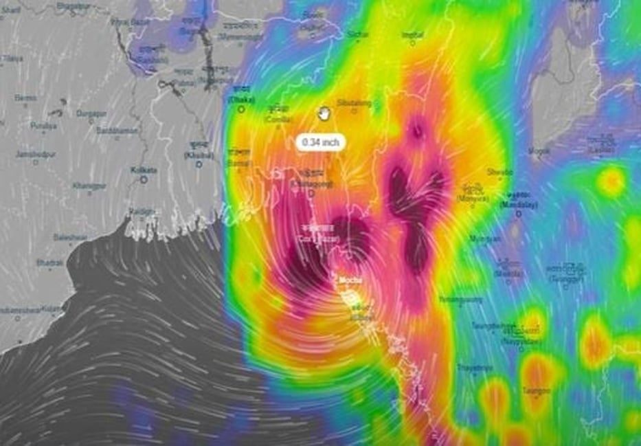
The “eye” or the centre point of most powerful cyclone in two decades, known as Mocha, made its landfall in south-eastern coastline ahead of the speculated timeline, making its way through the Naf River that divided Bangladesh and Myanmar, reports BSS.
“The ‘eye’ or the centre point of the cyclone made its landfall shortly after the midday today on the Teknaf shorelines, coming through the Naf River, ahead of the time what we had speculated,” Bangladesh met office spokesman AKM Nazmul Huda said on Sunday.
But, he said, the tail or the rest part of the severe storm, which was categorized as very dangerous Cat 5 cyclone, might take more time to land or cross the coastlines.
Meanwhile, Upazila Nirbahi Officer (UNO) Mohammad Quamruzzaman of Teknaf, which visibly bears the worst brunt of the cyclone, said the wind was blowing at a speed of over 200 kilometres per hour in Taknaf and its southernmost part Shahpori Dip along the Bay of Bengal.
“The weather is frightening because of the very high velocity of wind but we are yet to see the much feared massive tidal surges,” he said.
The weather officials said the Naf River was currently witnessing high-tide that began at 11 am and would continue until 5 PM, contrary to the low-tide in Cox’s Bazar, which started at 9 am and continued till 3 pm.
The officials and residents in Cox’s Bazar said cyclone Mocha was bringing with it heavy rain and winds of up to 195kph (120mph) and feared which could trigger dangerous flooding on land around the Bay of Bengal.
The storm surges of up to four metres could swamp villages in low lying areas but tensions grew about amid speculations that the storm could ravage the world’s largest refugee camp in Teknaf where over a million Rohingyas took makeshift refugees to evade persecution in their homeland in Myanmar.
Bangladesh authorities, however, moved to safety some half a million people while many of the Rohingyas living in risky foothills were relocated amid fears of mudslides.
Bd-pratidin English/Lutful Hoque


