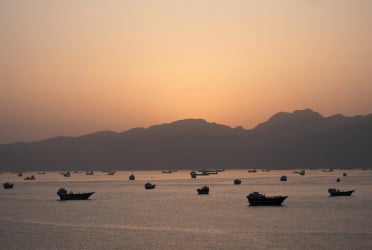
Bangladesh is slowly but steadily growing in size, as new islands continue to emerge along its southern coastline from the Bay of Bengal, offering hope in a country grappling with high population density and dwindling agricultural land.
Driven by the accumulation of sediments carried downstream by the Ganges-Brahmaputra-Meghna river system, vast tracts of land have risen from the sea over the past three decades. Areas once navigated by fishing trawlers are now dotted with rickshaws, trucks, and human settlements.
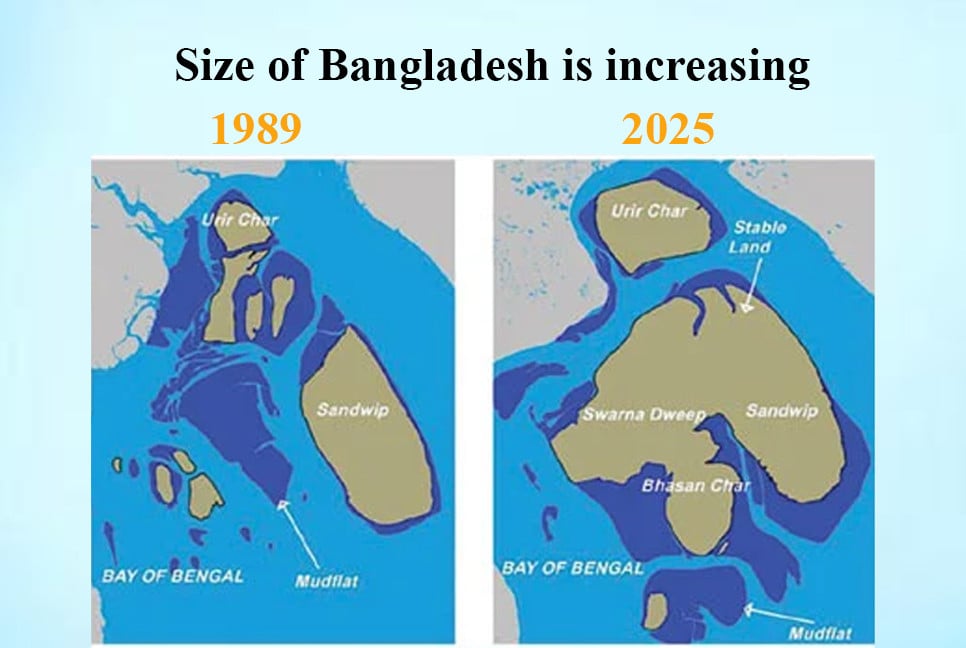
Research has shown that more than fifty island have been formed in the Meghna basin and along the coast. On average, the country's land area has increased by about 20 square kilometers every year. In addition, more than six hundred submerged islands, with a total area of more than 1,100 square kilometers, are raising their heads during low tide and making their presence known.
According to experts, if the submerged islands can be made sustainable through cross dams, mangrove afforestation, or any other technology, a large area will be added to the map of the country. The small country of 147,570 square kilometers is struggling to cope with the burden of a population of more than 170 million. The population is increasing every year. More than 1.2 million Rohingyas have added to the additional pressure. Agricultural land is constantly decreasing. In such a situation, experts are seeing a ray of hope in the hundreds of islands that have emerged in the Bay of Bengal.
The issue of islands emerging along the coast has been raised in a study titled ‘Land Area Expansion in the Eastern Part of Meghna Estuary Since the 1990s’ by the Bangladesh Space Research and Remote Sensing Organization (SPARSO).
The study was conducted by SPARSO member Dr. Mahmudur Rahman. The study used and analyzed satellite images from 1989 and 2025.
It was found that the permanent habitable land in and around Sandwip was 328 square kilometers in 1989, which increased to 726 square kilometers in 2025. Apart from this, 36 years ago, the submarine area was 335 square kilometers, which has now increased to 413 square kilometers. The places where there were submarine areas three decades ago have now become human settlements.
In the span of 36 years, the area of the island region of Sandwip has increased to 475 square kilometers. During this period, Swarnadwip and Bhasanchar have been formed from submarine areas.
Satellite images from SPARSO show that currently, more than six hundred submarine areas are rising up along the coast during low tide. Their total area is about 1,100 square kilometers. The largest submarine area is 85 square kilometers. It is also adjacent to Sandwip.
Researcher Dr. Mahmudur Rahman told Bangladesh Pratidin that approximately 1,600 million tons of sediment falls into the Bay of Bengal every year through the Ganges-Brahmaputra-Meghna river system. The main rivers of Bangladesh bring a huge amount of sediment from the Himalayas, which is the highest in the world.
“Due to this sediment, the shallow areas of the Bay of Bengal gradually become submerged and later they turn into vast areas. Again, some submerged areas are lost. However, with proper planning, the submerged areas can be converted into permanent islands. The Forest Department has planted Keora in some submerged areas, which has made them stable. This method is cost-effective. Apart from this, there are many other modern technologies including cross dams. The Netherlands has created a lot of land with cross dams,” he added.
A study of the Land Reclamation Project (LRP) on the Sandwip-Udirchar-Noakhali Cross Dam (1987) showed that the cross dam will give rise to about 18 thousand hectares of new land in the near future and another 18 thousand hectares of land in 30 years, which will directly benefit more than 1 lakh 80 thousand people.
Professor Dr. Saiful Islam of the Institute of Water and Flood Management, Bangladesh University of Engineering and Technology said, “A lot of sediment comes from outside the country through our rivers. A large part of it is lost in the depths of the Bay of Bengal. If the sediments can be blocked in a planned manner with cross dams, it is possible to create a lot of land in the coastal areas. The Netherlands created by filling small islands with cross dams. However, cross dams are expensive. This is the way to increase land quickly. Mangrove afforestation can also provide stability to islands at a low cost.”
BD-pratidin English/Tanvir Raihan